The Future of Drone Technology: Key Takeaways from the Commercial UAV Expo

At THE FUTURE 3D, we are driven by innovation. Our team recently attended the Commercial UAV Expo, a premier event for the drone industry, where we explored the latest advancements that are set to transform 3D modeling, surveying, and inspection services across various sectors, including construction, utilities, infrastructure, and mining.

Revolutionizing Operations with Cutting-Edge Drone Technology

Drone technology continues to revolutionize industries by providing more efficient, accurate, and safe solutions. At the expo, we encountered several groundbreaking advancements that will redefine how we serve our clients:

  1. Autonomous Flights: With advancements in autonomous flight technology, our drones can now conduct complex surveys and inspections without direct manual control. This means faster project completion, reduced risks, and more precise data capture.

  2. Thermal Inspections: With the integration of high-resolution thermal cameras, we can now provide real-time thermal inspections to detect heat loss, electrical faults, and water ingress, crucial for maintaining infrastructure health and energy efficiency.

  3. Ultra-High-Resolution 3D Modeling: Utilizing 100MP Phase One cameras, we are pushing the boundaries of what’s possible in 3D modeling. This technology allows for extremely detailed models that can detect even the smallest defects, facilitating proactive maintenance and ensuring the longevity of structures.

  4. AI-Powered Defect Detection: Artificial Intelligence is at the core of our new services. AI-powered defect detection allows us to automate the identification of potential issues, providing accurate, actionable insights faster than ever before. This proactive approach can save significant costs by preventing small problems from becoming major, expensive repairs.

  5. Expanding Our Service Capabilities: From topographic mapping for mining operations to detailed bridge inspections and utility line monitoring, the new technologies we’re adopting will significantly broaden the scope of our service offerings.

A Community of Innovators and Thought Leaders

We were honored to engage with some of the brightest minds and key players in the drone industry. Special thanks to industry leaders like Kyle Miller from DJI, Andrew Fore from Skydio, Stephen Licari-Maciong from SISO Air, Jack Ebert from Buzz Solutions, and others who shared their deep insights and experience. Their contributions are instrumental in pushing the boundaries of what drone technology can achieve.

Why Choose THE FUTURE 3D?

Our commitment to staying ahead of the curve means that our clients benefit from the latest and most effective technologies available. Whether it’s minimizing operational losses, enhancing data accuracy, or accelerating project timelines by up to 10 times, our advanced drone solutions are designed to deliver measurable value.

Join Us in Shaping the Future

We believe that embracing innovation is the key to growth and success in today’s fast-paced world. If you are looking to enhance your operations with state-of-the-art drone technology, connect with us at THE FUTURE 3D. Let’s discuss how we can work together to transform your business through the power of aerial data.

Looking Ahead

We are excited to integrate these advanced technologies into our service offerings. As we continue to innovate, we are committed to providing our clients with unparalleled solutions that not only meet but exceed expectations. Stay tuned for more updates as we lead the way in drone technology!

Ready to Experience the Future of Drone Services?

Take the next step and see how our cutting-edge drone solutions can transform your operations. Schedule a Zoom Demoor Call Us Today to discuss your specific needs and discover the value we can bring to your business!


BOOK A FREE DEMO

PICK THE BEST TIME FOR YOU. WE WILL MAKE IT WORK.

Bridge Inspections with AI-Powered Drones: A Modern Solution for Engineering Firms

Bridge inspections are critical for maintaining the safety and integrity of our infrastructure. However, traditional methods are often labor-intensive, risky, and costly. THE FUTURE 3D is leading a transformation in how these inspections are conducted, utilizing Skydio X10 drones equipped with Autonomous 3D Scan technology and GNext Labs’ AI-powered defect detection to provide a safer, faster, and more cost-effective solution.

The Challenges of Traditional Bridge Inspections

Traditionally, bridge inspections involve using scaffolding, bucket trucks, or even shutting down traffic lanes to allow inspectors to access hard-to-reach areas. These methods are not only time-consuming but also introduce significant safety risks for inspection teams. Additionally, the costs associated with such operations—ranging from equipment rental to the need for extensive labor—can be prohibitive, often exceeding $200,000 per inspection for large bridges.

How Skydio X10 Drones Overcome These Challenges

The Skydio X10 drone is a game-changer in the field of bridge inspections. Its advanced Autonomous 3D Scan capability allows it to navigate complex environments with ease, accessing areas that are difficult or impossible to reach with traditional methods. The drone’s AI-driven obstacle avoidance system ensures that it can safely fly close to structures, capturing detailed imagery and 3D models of the bridge’s condition.

This capability eliminates the need for scaffolding and reduces the duration of inspections by up to 75%. A bridge inspection that might traditionally take two weeks can be completed in just a few days, reducing costs by nearly 50%. For example, an inspection that could cost up to $211,000 using conventional methods can be reduced to around $105,000 with drone technology.

Enhanced Accuracy with AI-Powered Defect Detection

The integration of GNext Labs’ AI technology enhances the inspection process further by providing real-time analysis of the collected data. The AI algorithms can detect and classify defects such as cracks, corrosion, and other structural issues with greater precision than manual inspections. This ensures that no defect goes unnoticed, allowing for more accurate assessments and timely repairs.

Moreover, the AI system can track changes in defect size and location over time, enabling predictive maintenance and reducing the risk of sudden structural failures. This proactive approach not only improves safety but also optimizes maintenance budgets by prioritizing critical repairs.

The Financial and Operational Benefits

For engineering firms, adopting drone-based inspections with AI capabilities offers substantial financial benefits. By reducing the need for manual labor, equipment, and prolonged lane closures, firms can save up to 50% on inspection costs. Additionally, the time savings allow firms to take on more projects within a given period, increasing overall profitability.

For instance, a firm that might complete five traditional inspections per year could potentially double that number using drone technology, significantly boosting revenue. The increased accuracy and efficiency also mean fewer surprises down the line, further enhancing the value of the investment.

Why Partner with THE FUTURE 3D for Bridge Inspections?

1. Cost Savings: Reduce inspection costs by up to 50% through the elimination of expensive equipment and labor-intensive processes.
2. Increased Safety: Minimize risks to inspection teams by utilizing drones that can access even the most challenging areas safely.
3. Enhanced Accuracy: Benefit from AI-powered defect detection that ensures no issue is overlooked, enabling precise and timely maintenance decisions.
4. Scalability: Handle more projects in less time, increasing your firm’s capacity and revenue potential.

Take the Next Step with THE FUTURE 3D

At THE FUTURE 3D, we’re committed to revolutionizing the way bridge inspections are conducted. Our combination of Skydio X10 drones and AI-driven insights offers a superior solution that is safer, faster, and more cost-effective than traditional methods.

Contact us today to learn more about our services and how we can help you modernize your bridge inspection process. Visit thefuture3d.com to schedule a consultation and start transforming your inspections today.

Building Inspections with AI-Powered Drones: for Miami Engineering Firms and Condo Managers

In the aftermath of the Surfside condo collapse, Miami has ramped up its inspection requirements for older buildings, creating a pressing need for more efficient, accurate, and cost-effective solutions. Engineering firms and condo managers are now faced with the challenge of ensuring that their buildings meet these stringent new standards while keeping costs under control. THE FUTURE 3D is here to help, offering advanced drone-based inspection services that not only enhance safety and compliance but also provide significant cost savings.

Why Drones? The Skydio X10 Advantage

Traditional building inspections often involve scaffolding, cranes, and other heavy equipment—methods that are both time-consuming and costly. The Skydio X10 drone, equipped with Autonomous 3D Scan technology, offers a modern alternative. This drone provides high-resolution, comprehensive scans of building exteriors, delivering detailed data that is crucial for effective decision-making.

For engineering firms, this means the ability to conduct inspections without the need for extensive manual labor or the risks associated with working at heights. For condo managers, it translates to fewer disruptions for residents and a quicker path to compliance.

AI-Powered Defect Detection: Speed, Accuracy, and Cost Efficiency

The real power of our service lies in the combination of Skydio X10’s precise data collection and GNext Labs’ AI-powered defect detection. By using machine learning algorithms, GNext Labs can identify potential structural issues quickly and accurately, reducing the time needed for manual review.

By leveraging AI, we reduce the time engineers need to spend analyzing data by up to 70%. This efficiency directly translates into significant cost savings. For example, a traditional manual inspection might cost an engineering firm around $50,000, considering labor, equipment rental, and time. With THE FUTURE 3D’s drone-based inspection, these costs can be reduced by up to 40%, saving the firm $20,000 per project.

Additionally, the increased accuracy of AI detection minimizes the risk of missed defects, which can lead to costly repairs down the line. Avoiding even a single significant repair—such as fixing a structural crack that went unnoticed—can save up to $50,000 or more in potential damages and repairs.

For condo managers, the cost benefits are clear: faster inspections mean reduced service fees, fewer disruptions, and less time dealing with potential non-compliance issues. Considering that non-compliance fines can easily reach $10,000 to $25,000, a quick and accurate inspection can prevent these unexpected costs.

Value Proposition:

Why Engineering Firms and Condo Managers Should Partner with THE FUTURE 3D

1. Cost Savings: Save up to 40% on inspection costs by reducing the need for expensive scaffolding and cranes, and minimizing labor expenses.
2. Enhanced Safety: Reduce the risk associated with traditional inspection methods by using drones that can safely navigate complex structures.
3. Compliance and Risk Mitigation: Meet Miami’s stringent new inspection standards more easily, and minimize the risk of costly fines and repairs.
4. Increased Efficiency: AI-powered defect detection cuts down on analysis time, allowing for faster decision-making and quicker project turnaround.

Real-World Impact: The Financial Benefits

Consider this scenario: A condo building requires a comprehensive inspection to meet Miami’s updated safety regulations. Traditional methods might involve weeks of work and tens of thousands of dollars in equipment and labor. With THE FUTURE 3D’s drone-based inspection, the entire process can be completed in a fraction of the time and at a significantly lower cost.

For example, an inspection that would traditionally cost $50,000 can be completed for as little as $30,000 with our drone services, resulting in a direct savings of $20,000. This efficiency allows engineering firms to take on more projects in a shorter amount of time, increasing profitability by as much as 25% per year.

Condo managers benefit from fewer disruptions and faster resolution of potential issues, leading to happier residents and more predictable budgets. Avoiding fines and expensive emergency repairs can save property managers thousands, if not tens of thousands, of dollars annually.

Partner with THE FUTURE 3D Today

At THE FUTURE 3D, we understand the unique challenges that engineering firms and condo managers face in today’s regulatory environment. Our cutting-edge drone technology and AI-powered defect detection services offer a proven solution that delivers both cost savings and peace of mind.

Contact us today to learn more about how we can help you meet your building inspection needs efficiently and affordably. Visit thefuture3d.com to schedule a consultation and discover the future of building inspections.

Ensuring Building Safety with Drones: A New Era of Inspections in Miami

In the wake of the tragic Surfside condo collapse, the city of Miami has significantly ramped up its building inspection regulations. This disaster, which claimed the lives of 98 people in June 2021, highlighted the urgent need for more stringent and frequent inspections to ensure the safety of residential and commercial buildings. At THE FUTURE 3D, we are committed to providing cutting-edge drone services to enhance building safety inspections and reserve studies in Miami, FL.


The Rising Importance of Building Inspections

The collapse of the Champlain Towers South in Surfside was a sobering reminder of the potential dangers lurking in aging structures. This catastrophe prompted Miami-Dade County to enforce stricter building inspection protocols, particularly for buildings over 30 years old. These regulations aim to prevent such tragedies by identifying structural vulnerabilities before they become life-threatening.


How Drones Revolutionize Building Inspections

Traditional building inspections often require scaffolding, ladders, and manual labor, which can be time-consuming, costly, and sometimes dangerous. Drones, on the other hand, offer a safer, more efficient, and cost-effective alternative. Here’s how drones are revolutionizing the inspection process:

  1. Enhanced Safety: Drones can access hard-to-reach areas without putting human inspectors at risk. This is especially crucial for tall buildings or structures with limited accessibility.

  2. Comprehensive Data Collection: Equipped with high-resolution cameras and advanced sensors, drones can capture detailed images and videos of a building's exterior. This data can be used to create accurate 3D models and identify potential issues like cracks, water damage, or structural deformations.

  3. Efficiency and Speed: Drone inspections can be completed in a fraction of the time it takes for manual inspections. This means quicker assessments and faster implementation of necessary repairs or maintenance.

  4. Cost-Effectiveness: By reducing the need for extensive manual labor and equipment, drone inspections can significantly lower the overall cost of building assessments.


Reserve Studies and Long-Term Planning

In addition to immediate safety inspections, drones are invaluable tools for conducting reserve studies. These studies involve assessing the long-term maintenance needs of a building to ensure that sufficient funds are allocated for future repairs and replacements. With drones, we can:

  • Perform Detailed Condition Assessments: Drones can meticulously document the current state of a building, providing the data needed to project future maintenance requirements.

  • Monitor Structural Changes Over Time: By conducting regular drone inspections, we can track the progression of wear and tear, helping property managers plan and budget for necessary maintenance.


The Technology Behind Our Services

At THE FUTURE 3D, we leverage state-of-the-art hardware and software to deliver unparalleled drone inspection services. Our technology suite includes:

DJI Mavic 3 Enterprise RTK:

The DJI Mavic 3 Enterprise RTK is one of the primary drones we utilize for building inspections. This advanced drone offers:

  • RTK Precision: Real-Time Kinematic (RTK) positioning provides centimeter-level accuracy, crucial for creating precise 3D models and maps.

  • High-Resolution Imaging: The Mavic 3 Enterprise RTK is equipped with a powerful camera that captures stunningly detailed images and videos, enabling thorough inspections of building exteriors.

  • Extended Flight Time: With a longer battery life, this drone can cover large areas in a single flight, making it highly efficient for extensive property inspections.


Skand.io:

We use Skand.io, a cutting-edge software platform, for AI-based defect analysis and reporting. Skand.io offers:

  • Automated Defect Detection: The AI algorithms in Skand.io analyze drone-captured images to identify defects such as cracks, spalling, and water damage with high accuracy.

  • Comprehensive Reporting: The software generates detailed reports, highlighting areas of concern and providing actionable insights for maintenance and repair.

  • Data Management: Skand.io organizes and stores inspection data, making it easy to track the condition of buildings over time and plan for future inspections.

Additional Technologies:

To ensure the highest quality of our services, we also incorporate:

  • Thermal Imaging Cameras: These cameras detect heat patterns, identifying issues like moisture intrusion, insulation defects, and electrical faults that are not visible to the naked eye.

  • LiDAR Sensors: LiDAR (Light Detection and Ranging) technology provides precise measurements of a building’s structure, helping to create accurate 3D models and identify structural anomalies.

  • 3D Modeling Software: Our 3D modeling tools transform drone-captured data into detailed, interactive 3D models, offering a comprehensive view of the building's condition.


THE FUTURE 3D: Leading the Way in Drone Inspections

At THE FUTURE 3D, we leverage state-of-the-art drone technologies to provide comprehensive building safety inspections and reserve studies in Miami. Our team of certified drone pilots and inspection experts is dedicated to delivering precise, reliable, and timely assessments to keep your properties safe and compliant with new regulations.

Our services include:

  • Detailed Structural Inspections: Using high-resolution imagery and 3D modeling, we identify and document potential structural issues.

  • Thermal Imaging: Our drones are equipped with thermal cameras to detect hidden problems such as moisture intrusion or insulation defects.

  • Compliance Reporting: We provide thorough reports that meet the latest regulatory standards, ensuring that your building inspections are fully compliant with Miami-Dade County requirements.


Conclusion

The Surfside tragedy has underscored the critical need for rigorous building inspections and proactive maintenance planning. Drones offer a powerful solution to these challenges, providing enhanced safety, efficiency, and accuracy. At THE FUTURE 3D, we are proud to be at the forefront of this technological revolution, helping to ensure the safety and longevity of buildings throughout Miami.

For more information about our drone inspection services or to schedule an inspection, visit us at thefuture3d.com.

By incorporating drones into your building inspection and reserve study processes, you can rest assured that your properties are being evaluated with the latest technology, ensuring the highest standards of safety and compliance.


BOOK A FREE DEMO

PICK THE BEST TIME FOR YOU. WE WILL MAKE IT WORK.

Exploring the Latest Use Cases of DroneDeploy with THE FUTURE 3D

The integration of cutting-edge drone technology in various industries has revolutionized how businesses operate and gather data. At THE FUTURE 3D, we pride ourselves on being at the forefront of this technological wave, providing top-notch drone services that enhance precision, efficiency, and safety in numerous fields. Leveraging the powerful capabilities of DroneDeploy, a leading drone software platform, we offer unparalleled services that set us apart in the industry. Here are some of the latest use cases of DroneDeploy that showcase the transformative impact of our drone services.

1. Construction Site Management

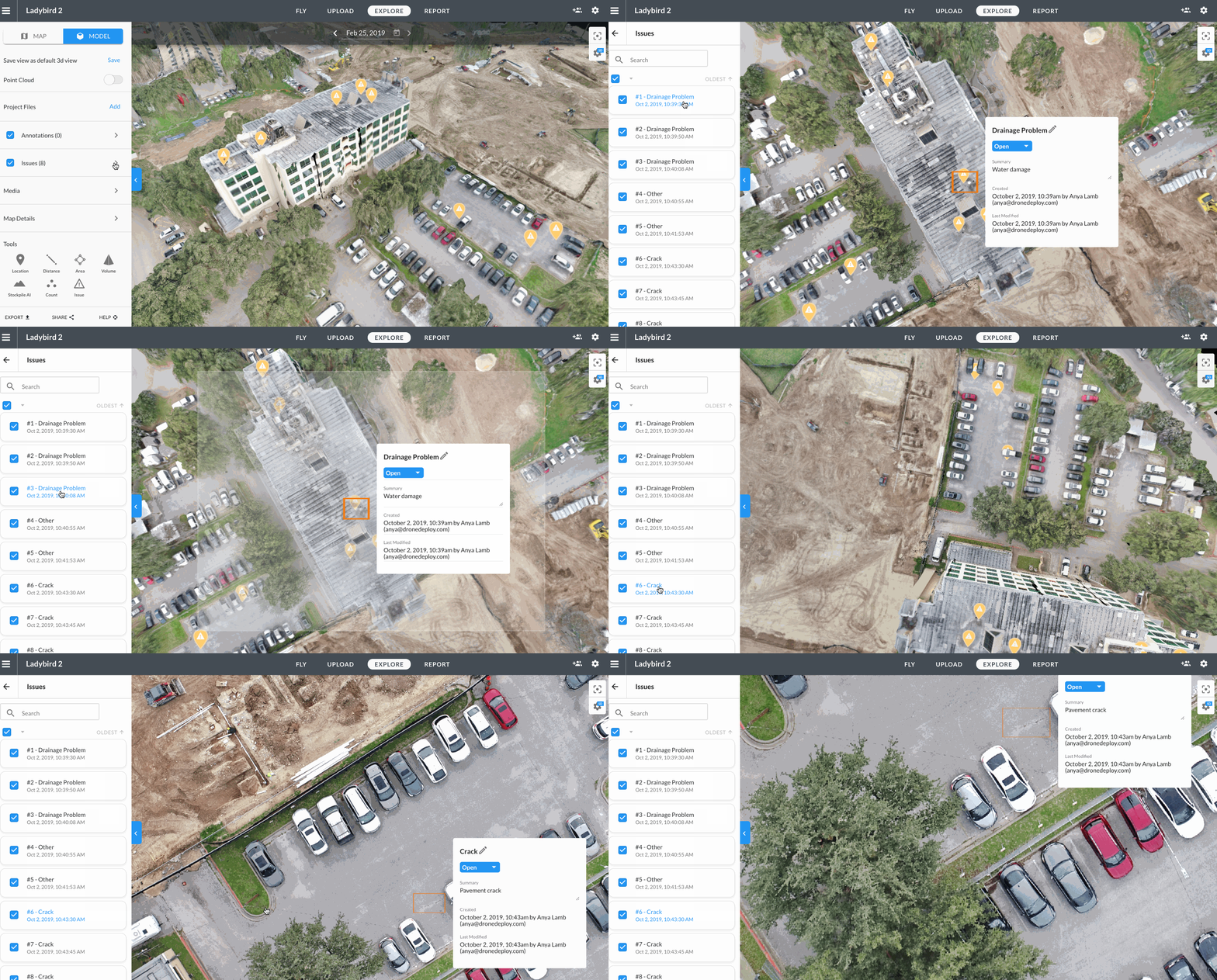
DroneDeploy's advanced mapping and analytics capabilities are invaluable for construction site management. At THE FUTURE 3D, we use DroneDeploy to create detailed 3D models and orthomosaic maps of construction sites, allowing project managers to monitor progress with precision. This real-time data helps in identifying potential issues, optimizing resource allocation, and ensuring projects stay on schedule and within budget. By providing a comprehensive aerial view, we enable better decision-making and enhance overall project efficiency.

2. Agricultural Monitoring

Agriculture has seen significant advancements with the use of drone technology, and DroneDeploy is at the heart of this transformation. Our services at THE FUTURE 3D include crop health analysis, field mapping, and irrigation management. Using DroneDeploy, we deliver detailed insights into crop conditions, helping farmers make informed decisions about planting, fertilizing, and harvesting. This precision agriculture approach reduces waste, increases yields, and promotes sustainable farming practices.

3. Roof Inspections

Roof inspections have traditionally been time-consuming and hazardous. With DroneDeploy, we streamline this process, making it faster, safer, and more accurate. THE FUTURE 3D uses drones equipped with high-resolution cameras and thermal sensors to conduct thorough inspections of residential and commercial roofs. This technology allows us to detect issues such as leaks, cracks, and insulation problems without the need for manual inspections. Our clients benefit from detailed reports and actionable insights, enabling timely maintenance and repairs.

4. Environmental Conservation

Environmental conservation efforts have greatly benefited from drone technology, and DroneDeploy plays a crucial role in this domain. At THE FUTURE 3D, we assist conservationists in monitoring wildlife habitats, tracking animal movements, and assessing environmental changes. The data collected through DroneDeploy is used to create detailed maps and 3D models, aiding in the development of conservation strategies. This technology allows for non-intrusive monitoring, ensuring minimal disturbance to wildlife.

5. Disaster Response and Management

In times of disaster, quick and accurate data collection is critical for effective response and recovery. THE FUTURE 3Dleverages DroneDeploy to provide rapid aerial assessments of disaster-stricken areas. Our drones capture high-resolution images and generate 3D models that help emergency responders assess damage, plan rescue operations, and allocate resources efficiently. This technology is instrumental in minimizing response times and improving the overall effectiveness of disaster management efforts.

6. Real Estate and Property Management

The real estate industry is another sector where DroneDeploy has made significant inroads. At THE FUTURE 3D, we use drones to create stunning aerial photography and 3D virtual tours of properties. These visuals provide potential buyers with a comprehensive view of the property, enhancing the marketing efforts of real estate agents. Additionally, DroneDeploy's precise mapping capabilities are used for property inspections, land surveys, and development planning.

7. Infrastructure Inspection

Inspecting infrastructure such as bridges, power lines, and pipelines is a challenging and often dangerous task. DroneDeploy enables us to conduct these inspections safely and efficiently. At THE FUTURE 3D, our drones capture high-resolution imagery and thermal data, identifying structural issues and areas of concern. This information is crucial for maintenance planning and ensuring the safety and reliability of critical infrastructure.

Conclusion

At THE FUTURE 3D, we are dedicated to harnessing the full potential of DroneDeploy to deliver exceptional drone services across various industries. Our expertise and innovative approach make us the go-to provider for precision data collection and analysis. Whether you are in construction, agriculture, real estate, or environmental conservation, our drone services can elevate your operations to new heights. Visit thefuture3d.com to learn more about how we can help you achieve your goals with the power of DroneDeploy.


BOOK A FREE DEMO

PICK THE BEST TIME FOR YOU. WE WILL MAKE IT WORK.

The Power Of Drone Photogrammetry For Building Inspection

In the evolving landscape of construction and building management, the drive for efficiency, safety, and precision has never been more critical. At THE FUTURE 3D, we stand at the forefront of integrating cutting-edge technologies into everyday operations, revolutionizing how buildings are inspected, maintained, and managed. One such technology that is changing the game is drone photogrammetry, a method that harnesses the capabilities of UAVs (Unmanned Aerial Vehicles) to collect high-resolution imagery for detailed analysis.

What is Drone Photogrammetry?

Drone photogrammetry involves the use of drones equipped with advanced imaging technologies to capture a series of photographs from various angles around a building. These images are then processed using specialized software to create detailed 3D models and maps. This innovative approach offers unparalleled precision in inspecting buildings, infrastructures, and even entire cityscapes, making it an indispensable tool for architects, engineers, and construction managers.

How It's Done

The process begins with a drone, such as the DJI Mavic 3 Enterprise RTK, taking flight to capture high-quality images from predetermined flight paths. These images are intricately stitched together using software solutions like DroneDeploy or Pix4D, creating highly accurate 3D representations of the structures.

Applications and Clients

Drone photogrammetry is versatile, finding applications in a wide array of projects - from the inspection of high-rise buildings in urban centers like Miami, FL, and New York to monitoring construction progress in sprawling residential developments across Los Angeles and nationwide. It serves an essential role in:

  • Structural inspections and maintenance

  • Pre-construction site surveys

  • Monitoring construction progress

  • Roof inspections

  • Infrastructure analysis

This technology is particularly beneficial for clients ranging from construction companies and real estate developers to governmental bodies and architectural firms, providing them with detailed insights that were previously unattainable without significant time and financial investment.

Why Use Drone Photogrammetry?

The advantages of drone photogrammetry are manifold:

  • Enhanced Safety: It significantly reduces the need for manual inspections in hard-to-reach areas, thereby minimizing risk.

  • Cost Efficiency: Drone inspections are faster and less labor-intensive, reducing operational costs.

  • Precision and Accuracy: The technology offers detailed and accurate data, aiding in better decision-making.

  • Time-saving: Quick deployment and rapid data collection mean that projects can move forward without delay.

By incorporating drone photogrammetry into their operations, companies can not only enhance the efficiency and safety of their projects but also gain a competitive edge in the market.

Leading Industry Tools

To achieve the best results in drone photogrammetry, utilizing top-tier tools and software is paramount. Here are some recommendations:

  • DJI Mavic 3 Enterprise RTK - Ideal for capturing precise, high-resolution images.

  • DroneDeploy - Offers comprehensive drone mapping solutions.

  • Pix4D - Specializes in creating accurate 3D models from drone-captured images.

  • Skand - Provides innovative solutions for analyzing and managing the resulting data.

Locations We Serve

At THE FUTURE 3D, our services span across key locations, including Miami, FL; New York; New Jersey; Connecticut; Los Angeles; and nationwide across the U.S. Our team of experts is equipped to bring the benefits of drone photogrammetry to your next project, regardless of its location.

Conclusion

Drone photogrammetry is more than just a technological innovation; it's a strategic asset that can significantly enhance the quality, safety, and efficiency of building inspections. As the industry evolves, THE FUTURE 3D remains committed to offering cutting-edge solutions to our clients, ensuring that they stay ahead in a competitive landscape.

For those looking to integrate drone photogrammetry into their operations, partnering with a leader in the field is essential. Visit our website at www.thefuture3d.com to discover how we can transform your project management and inspection processes with the power of drone technology.


BOOK A FREE DEMO

PICK THE BEST TIME FOR YOU. WE WILL MAKE IT WORK.

Exploring the Power of LiDAR Drone Scanning with THE FUTURE 3D

LiDAR (Light Detection and Ranging) technology has experienced a revolutionary advancement in recent years, especially in its integration with drones. Businesses and organizations are realizing its potential, and the results are transformative. As we delve into the capabilities of LiDAR drone scanning, it's worth noting how pioneering companies like THE FUTURE 3D are at the forefront of bringing these technologies to clients across Miami, FL; New York; New Jersey; Connecticut; Los Angeles, and nationwide U.S.

What is LiDAR Drone Scanning?

LiDAR is a remote sensing method that uses light in the form of a pulsed laser to measure distances. When mounted on drones, LiDAR systems can scan vast expanses of land with incredible accuracy. These drones send out thousands of laser pulses every second, which bounce back after hitting objects on the ground. This data is then processed to produce detailed, three-dimensional images of the surveyed area.

How is it Done?

Drones equipped with LiDAR sensors, such as the industry-leading DJI M350 RTK, fly over designated areas, sending laser beams to the ground. The time taken for the light to reflect back to the sensor provides a precise distance measurement. The resulting dataset, combined with GPS and IMU (Inertial Measurement Unit) data, delivers accurate topographical maps and 3D models.

Suitable Projects for LiDAR Drone Scanning

  1. Forestry: For assessing forest canopy and biomass estimation.

  2. Archaeology: To uncover and document buried historical sites.

  3. Urban Planning: Detailed 3D mapping of cities and towns for infrastructural development.

  4. Environmental Monitoring: Understanding terrain changes, watershed modeling, and flood risk analysis.

  5. Construction and Mining: Accurate volume measurements and site progress tracking.

Who Needs LiDAR Drone Scanning?

From architects and city planners to environmentalists and construction giants, the application of LiDAR drone scanning spans various industries. Businesses striving for accuracy in topographical data, comprehensive site surveys, and cost-effective solutions are turning to companies like THE FUTURE 3D for these cutting-edge services.

  1. Real Estate Developers: For precise land surveys and topographical analyses.

  2. Government Agencies: Urban planning, environmental monitoring, and disaster management.

  3. Utilities: For infrastructure planning and management.

Why Opt for LiDAR Drone Scanning?

  1. Precision: With advanced drones like the Rock R3PRO, LiDAR scanning offers unparalleled accuracy.

  2. Speed: Cover vast areas in a fraction of the time compared to traditional methods.

  3. Safety: Survey hazardous areas without putting personnel at risk.

  4. Cost-Effective: Reduction in man-hours and logistics-related costs.

Conclusion

In a rapidly evolving technological landscape, staying updated is the key to success. With the transformative power of LiDAR drone scanning, businesses have an opportunity to elevate their operations, improve efficiency, and cut costs. If your projects demand accuracy, speed, and the best in technology, it's time to explore what THE FUTURE 3D, with its nationwide presence, has to offer. Dive into the future, and harness the power of LiDAR with THE FUTURE 3D.


BOOK A FREE DEMO

PICK THE BEST TIME FOR YOU. WE WILL MAKE IT WORK.

The Connection Between Photogrammetry and 3D Modeling: The Future of Precision Design

In an age dominated by technology and the quest for vivid visualization, both photogrammetry and 3D modeling are emerging as revolutionary tools that can transform industries. But what's the connection between the two, and how does it enhance the services we provide at THE FUTURE 3D? Let's dive deep into this transformative connection.

Understanding Photogrammetry

Photogrammetry is the art, science, and technology of obtaining reliable spatial and geometric information about physical objects and the environment through the process of recording, measuring, and interpreting photographic images. In simpler terms, it's a technique to achieve 3D data from photographs.

The World of 3D Modeling

3D modeling, on the other hand, is the process of creating a three-dimensional representation of any surface or object using specialized software. The product is called a 3D model, and it can be displayed as a two-dimensional image or animated as a living organism.

Making the Connection

The beauty lies in the connection: photogrammetry provides the raw data, and 3D modeling transforms that data into a tangible, visual representation. By taking photographs from different viewpoints, one can use photogrammetry to create detailed 3D models of almost anything - from large landscapes to tiny artifacts.

Projects and Applications

The combined power of photogrammetry and 3D modeling is being utilized in:

  1. Architecture and Construction: For detailed site surveys, planning, and visualizations. Firms can gain accurate dimensions and plan accordingly.

  2. Archeology: To create detailed replicas and digital archives of artifacts and historical sites.

  3. Film and Gaming: For creating lifelike environments and objects.

  4. Urban Planning: For better city modeling and infrastructure development.

Autodesk, an industry leader in 3D design, has highlighted the importance of photogrammetry in modern design through various blog posts and case studies.

Target Audience: Who Needs This?

If you're in any industry that requires detailed visualization or representation, such as real estate, construction, film, gaming, urban development, or archaeology, this fusion technology is crucial.

  1. Real estate companies looking for accurate property visualization.

  2. Film studios in need of realistic environments or assets.

  3. Construction firms aiming for precision in their projects.

  4. Game developers wanting to elevate their gaming experience.

Why Choose Photogrammetry and 3D Modeling for Your Operations?

  1. Precision and Accuracy: Achieve detailed and accurate 3D models.

  2. Cost-Efficient: Reduce the need for manual site visits or measurements.

  3. Enhanced Visualization: Provide clients with a vivid representation of your product or site.

  4. Competitive Advantage: Stay ahead of the curve with cutting-edge technology.

Pix4D, another industry trailblazer, offers insights on how businesses have enhanced their operations using photogrammetry in their blog section.

Our Reach

We at THE FUTURE 3D are proud to offer our exceptional services in:

  • Miami, FL

  • New York

  • New Jersey

  • Connecticut

  • Los Angeles

  • And nationwide across the U.S.

Conclusion

The fusion of photogrammetry and 3D modeling isn't just a tech trend—it's a game-changer for industries aiming for perfection in representation and planning. Join us on this journey at THE FUTURE 3D as we shape the future of design and visualization.


BOOK A FREE DEMO

PICK THE BEST TIME FOR YOU. WE WILL MAKE IT WORK.